
LiDAR Drone Market Share, Size, Trends, Industry Analysis Report, By Type (Fixed-Wing, Rotary-Wing); By Range; By Component; By Application (; By Regions; Segment Forecast, 2024 - 2032
- Published Date:Jan-2024
- Pages: 119
- Format: PDF
- Report ID: PM1678
- Base Year: 2023
- Historical Data: 2019-2021
Report Outlook
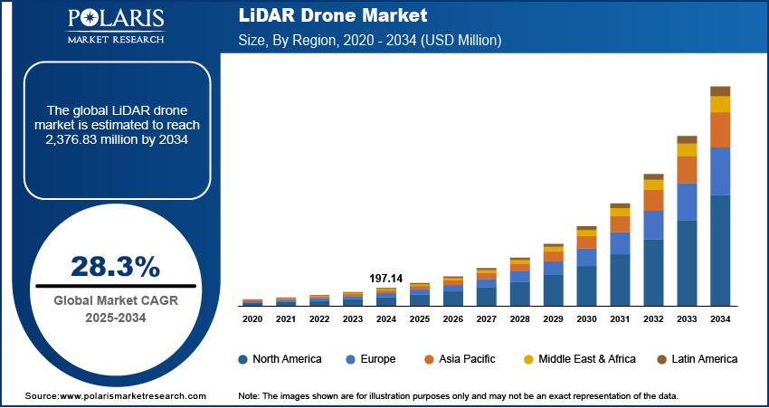
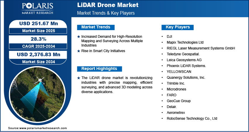
The global LiDAR drone market was valued at USD 255.66 million in 2023 and is expected to grow at a CAGR of 27.60% during the forecast period. The growing use of LiDAR drones across various end-user verticals such as agriculture, forestry, natural resource management, oil and gas exploration, and others, coupled with technological advancements in the drone industry in the last few years, are primarily driving the market.
Know more about this report: Request for sample pages
LiDAR drones utilize light energy and lasers to scan and measure the target from distance. They send out multidirectional laser pulses using oscillating mirrors to map ground points and terrain through analysis of returning vibrations. The automation of LiDAR drones requires processing systems involving various combinations of scientific algorithm computation and cloud-based processing of captured data points for sophisticated analysis. The algorithm makes the LiDAR drones more accurate and efficient in detecting the target objects.
The sensors generally measure time, intensity, and angle of reflection to understand an object in three dimensions. After collecting the data points, the 3D mapping software processes the information along with GPS data and Inertial Navigation System to make a detailed and precise 3D model of a targeted area and object.
The advancement of technology has enabled LiDAR drones to capture the data more 3D pictures more accurately, which increases its adoption in a broad range of applications. The most common areas in which LiDAR scanner drones are used are accident scenes, agriculture, archeology, conservation, inspections, insurance, law enforcement, forestry, and mining.
Government and private firms engaged in construction, engineering and mining, surveying, land management, and planning are likely to contribute to the increase in demand for LiDAR drones in the coming years. Optimizing traffic flow, better route planning and design, detailed topographic models, 3D modeling, and reconstruction are some factors leading to the increasing utilization of imagine solutions in civil engineering.
The major restraining factors for the LiDAR drone market is the associated high cost of the equipment used in the technology. Various components such as laser scanners, high-resolution three-dimension cameras, global navigational satellite systems (GNSS), and UAV camera navigation systems have all added to the expense of the system. Further, drones require high input power from batteries for surveying applications, increasing overall purchasing and operational costs.
In addition, the stringent regulations and restrictions relating to using drones in certain countries have remained a limiting factor for the growth of the LiDAR drone market. Companies are incurred high registration fees before flying drones, also restraining the growth in some countries such as Kuwait, Iran, Sri Lanka, and Uzbekistan.
The COVID-19 pandemic has negatively impacted the LiDAR drone market across all regions. Various countries' governments have imposed certain measures to control the virus to further spread among the people. The temporary shutdown of multiple shops and production units led to disruption in scheduled mapping, exploration and detection, precision application operations, and surveillance and, in turn, reduced the application of drones during the pandemic period.
Know more about this report: Request for sample pages
Industry Dynamics
Growth Drivers
The increasing demand for a 3D imaging system in a wide range of applications is the primary driving factor for the LiDAR drone market. One such application is the adoption of LiDAR drones in the mining industry. The LiDAR-based technology has enabled mining organizations to measure the 3D coordinates of various objects on the ground and applies a point cloud filtering method to generate a precision digital terrain model. Corridor mapping remained the second most important area where the LiDAR drone has been widely used. Experts and engineers prefer to use the technology to create 3D models of motorways, trains, shoreline structures, bridges, roadways. In the last few years, a spike in the applications of LiDAR drones has witnessed due to satisfactory solutions of the technology in remote sensing platforms applications and other archaeological surveys.
The increasing investment in the R&D of LiDAR drones has improved the capability to capture data more precisely and accurately. The advancement of dynamic sensor technologies has widened the scope of drones for accident prevention and other warning systems. The rise of active sensor technologies has allowed various manufacturing companies to select products cost-effectively. The improvement in the efficiency of LiDAR drones in the last decade has widened its scope of application and is fueling the market in the coming years.
Report Segmentation
The market is primarily segmented based on form, product, application, and region.
|
By Component |
By Product |
By Range |
By Application |
By Region |
|
|
|
|
|
Know more about this report: Request for sample pages
The Rotary Wing LiDAR Drone segment is anticipated to hold the largest market share in 2022
The primary factors driving the Rotary wing LiDAR drone segment can be attributable to the rise in the adoption of the single-rotor and multirotor Unmanned Aerial vehicles across various regions. Rotary-wing LiDAR drone offers a cost-effective benefit in 3D image mapping applications compared to fixed-wing drones. In addition, the multirotor LiDAR drone is gaining popularity due to its easy flight controlling systems over conventional products and provides for covering the vast area for mapping various forests, terrains and farms.
Meanwhile, the fixed-wing segment in the LiDAR drone market is anticipated to witness a significant growth rate due to increasing demand BLOs operations with increased payload capacity and long-range detection.
The Short-Range segment accounted to witness significant market share in 2022
The short-range segment is projected to hold the major share in the LiDAR drone market owing to factors such as excess adoption in low-altitude applications and low costs.
The long-range segment is anticipated to witness a significant growth rate in the LiDAR drone market attributed to the rising development of advanced laser technology to offer improved and accurate detection from high altitudes.
North America is projected to dominate the market in 2022
North America will hold a significant share of the LiDAR drone market in the forecast period. The primary factors responsible for the major share of North America include increasing investments towards better and innovative defense tools. The accuracy and efficiency of LiDAR drones to collect data from high altitudes have increased their adoption in the defense sector in the last few years. Further, a country like the USA has the world's highest military budget with a significant investment in defense tools coupled with supportive government regulations towards integrating the technology in the defense sector fueled the market in the North America region.
Asia Pacific is projected to witness the highest growth in the LiDAR drone market owing to factors such as the rising number of commercial drones and its component manufacturers in countries such as India and China. Further, drones have been widely demanded by the agricultural sector of Asian countries for various key applications such as precision farming and disease-controlling studies.
Competitive Insight
Some of the major players operating in the global market include Velodyne Lidar, Inc., Inc., Phoenix LiDAR Systems, YELLOWSCAN, Teledyne Technologies Incorporated, RIEGL Laser Measurement Systems GmbH, LiDARUSA, DJI, Delair, Leica Geosystems AG, SICK AG, Benewake (Beijing) Co., Ltd., RoboSense, MICRODRONES
Recent Developments
In February 2023, Robosense has announced the partnership agreement with Toyota, a leading car manufacturer to supply RS-LiDAR-M series, which empowers the Toyota cars with accurate perception and improves the driving safety of its cars.
In February 2023, Delair, a France based company engaged in high performance drone-based solutions, has announced its acquisition to Notilo Plus to further expand its portfolio in aeriel and underwater drones.
LiDAR Drone Market Report Scope
|
Report Attributes |
Details |
|
Market size value in 2024 |
USD 325.61 million |
|
Revenue forecast in 2032 |
USD 2,286.09 million |
|
CAGR |
27.60% from 2023 - 2032 |
|
Base year |
2023 |
|
Historical data |
2019 - 2021 |
|
Forecast period |
2024 - 2032 |
|
Quantitative units |
Revenue in USD million and CAGR from 2024 to 2032 |
|
Segments covered |
By Component, By Product, By Range, By Application, By Region |
|
Regional scope |
North America, Europe, Asia Pacific, Latin America; Middle East & Africa |
|
Key companies |
Velodyne Lidar, Inc., Inc., Phoenix LiDAR Systems, YELLOWSCAN, Teledyne Technologies Incorporated, RIEGL Laser Measurement Systems GmbH, LiDARUSA, DJI, Delair, Leica Geosystems AG, SICK AG, Benewake (Beijing) Co., Ltd., RoboSense, MICRODRONES |
Uncover the dynamics of the LiDAR Drone sector in 2024 with detailed statistics on market share, size, and revenue growth rate meticulously curated by Polaris Market Research Industry Reports. This all-encompassing analysis extends to a forward-looking market forecast until 2032, complemented by a perceptive historical overview. Immerse yourself in the profound insights offered by this industry analysis through a complimentary PDF download of the sample report.
Browse Our Top Selling Reports
Health & Hygiene Packaging Market Size, Share 2024 Research Report
Spinal Implants Market Size, Share 2024 Research Report
Polyethylene Furanoate (PEF) Market Size, Share 2024 Research Report
Oil Immersed Power Transformer Market Size, Share 2024 Research Report
Artificial Flowers Market Size, Share 2024 Research Report
FAQ's
key companies in lidar drone market are Velodyne Lidar, Inc., Inc., Phoenix LiDAR Systems, YELLOWSCAN, Teledyne Technologies Incorporated, RIEGL Laser Measurement Systems GmbH, LiDARUSA, DJI, Delair, Leica Geosystems AG, SICK AG, Benewake (Beijing) Co., Ltd.
The global lidar drone market expected to grow at a CAGR of 27.6% during the forecast period.
The lidar drone market report covering key segments are form, product, application, and region.
key driving factors in lidar drone market are growing investments in smart city projects and rising adoption of LiDAR drone for mining application.
The global LiDAR drone market size is expected to reach USD 2,286.09 million by 2032.