
Drone Mapping Software Market Share, Size, Trends, Industry Analysis Report, 2021 - 2028
REPORT DETAILS
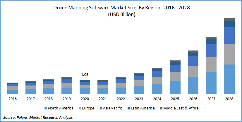
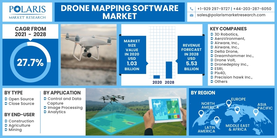
The global drone mapping software market was valued at USD 1.03 billion in 2020 and is expected to grow at a CAGR of 27.7% during the forecast period. The growing innovation in commercial and military applications insisted the industries utilize advanced solutions and software that positively influence the drone mapping software. This software is specifically designed to meet the requirements of the industrial sector for automating both drone flight and image data transfer, along with providing survey-grade results to the sub-centimeter level.
Source: Polaris Market Research Analysis
Know more about this report: Download Sample Report
In addition, the gradual shift towards innovative drones incorporated with mapping software resulted in the reduced field time and survey cost, reduced business complexities, improved flexibility, and loss of productivity. Thus, the adoption of digital and innovative solutions in the industrial sector is augmenting the market growth outlook for the global drone mapping software market.
The outbreak of the COVID-19 pandemic is widespread around the world, tapping communities, countries, and societies under massive pressure. Several governments from the different geographic regions have further enforced stringent lockdowns and social distancing policies to reduce the spread of novel coronavirus, which are now widely acknowledged as the most effective way to combat the pandemic. Therefore, there was a temporary reduction observed in mapping software usage because of the nationwide lockdown and economic distress in this pandemic. As a result, the drone mapping software market has been experiencing a significant downfall in recent years.
Source: Polaris Market Research Analysis
Know more about this report: Download Sample Report
Industry Dynamics
Growth Drivers
Drone mapping software has observed an increased adoption backed by the surging penetration of the IoT and the Industrial Internet of Things (IIoT) technology. The unmanned vehicle plays an integral role, particularly where it is costly, risky, or impossible for humans to reach. In such a context, unmanned vehicles can often make travel faster or accomplish a task more effectively with the involvement of less risk. This, in turn, is projected to drive the growth of the drones mapping software market.
Furthermore, the IoT-based technology in unmanned vehicles also provides a wide range of functionalities to aid their intended uses. For instance, GPS and Radios technology helps for gathering location information and data transfer, video and cameras aids in recording positioning of objects and allow a proper survey of the area. Apart from these factors, the increased proliferation of virtual reality (VR) and artificial intelligence (AI) technology in the end-use verticals further strengthens the market demand for unmanned vehicle mapping software all over the world. The integration of AI-based unmanned vehicle mapping software enables users to work with higher levels of abstraction.
It further utilizes sensors to evaluate, capture, transmit, and store several layers of identifying trends data, and patterns in real-time. Thus, the key players' technological breakthrough in such software supports substantial drone mapping software market growth over the foreseen period. For instance, in March 2020, PIX4D unveiled a new generation tool for photogrammetry, unmanned vehicle mapping, and analytics, which eventually addressed the modern challenges and delivered productive services.
Report Segmentation
The market is primarily segmented on the basis of type, application, end-use, and region.
| By Type | By Application | By End-User | By Region |
|
|
|
|
Source: Polaris Market Research Analysis
Know more about this report: Download Sample Report
Insight by Type
Based on the type segment, the open-source segment held the most significant mapping market capture in the global market in 2020. Open-source unmanned vehicle mapping software is increasingly preferred, owing to its extensive adoption of high compatible systems.
Furthermore, open-source mapping software is readily available for users worldwide as they are generally free of cost, which eventually provides the flexibility to the consumer to use such software anywhere, at a particular point in time. In addition, the trend in drone mapping software towards the open source is that the end-users need customized software for functioning drones. These key benefits are expected to fuel the market demand for the open-source segment in the global mapping market.
On the contrary, the closed source segment is expected to register a considerable share in terms of revenue in the global market. The surging market demand for customized and secured architecture in unmanned aerial mapping vehicles software for military and commercial users is likely to promote the market demand for closed-source drone mapping software worldwide. Companies are also taking a keen interest in collaboration with technology companies to advance their software. For instance, in February 2021, SenseFly launched the expansion of its flagship solution - eBee Geo, which is positioned as a cost-effective choice for surveyors. Therefore, this factor will act as a key factor for driving the market growth worldwide.
Geographic Overview
Geographically, North America is leading the global market in 2020 and is estimated for the largest share in terms of revenue due to the rising usage of drone mapping software in mining activities as it improves efficiency and operating capabilities.
According to the United States Geological Survey (USGS), in 2018, the mines produced across the United States were USD 82.2 billion of raw mineral materials, demonstrating a surge of 3% over the total value of USD 79.7 billion in 2017. This, along with the rise in the presence of commercial unmanned aerial vehicle manufacturers in both the United States and Canada, is further responsible for the region's dominance. Positive trends in the growing focus on technological innovation and commercial drone mapping at reasonable cost are also the primary drivers of successful product uptake.
Europe's market is mainly driven by the rising drone mapping services, owing to the increasing market demand for commercial and military drones mapping coupled with the growing disposable income in the region's emerging economies. Further, most of the functional companies in this region emphasize advancing low-cost and innovative autonomous unmanned aerial vehicles, coupled with improved landing capability, which also is a prime factor for driving the region's growth.
Moreover, Asia-Pacific held a high CAGR in the global market in 2020. The expansion of multinational firms in these emerging countries of Asia is leading to the rise in the adoption of unmanned aerial vehicles in diverse industry verticals, such as infrastructure, construction, mining, and agriculture. Moreover, the government initiatives for promoting and advanced technologies in the agriculture sector, along with the development of automated drones, are some other factors leading to the region's growth.
Competitive Insight
Some of the major market players operating in the global market include:
- 3D Robotics,
- AeroVironment,
- Airware, Inc.,
- Airware, Inc.,
- Delta Drone,
- Dreamhammer Inc.,
- Drone Volt,
- Dronedeploy Inc.,
- ESRI,
- Pix4D,
- Precision hawk Inc.,
- Sensefly Ltd.,
- Skyward Io,
- VIATechnik.
Drone Mapping Software Market Report Scope
| Report Attributes | Details |
| Market size value in 2020 | USD 1.03 billion |
| Revenue forecast in 2028 | USD 5.53 billion |
| CAGR | 27.7% from 2021 - 2028 |
| Base year | 2020 |
| Historical data | 2016 - 2019 |
| Forecast period | 2021 - 2028 |
| Quantitative units | Revenue in USD million/billion and CAGR from 2021 to 2028 |
| Segments covered | By Type, By Application, By End-Use, By Region |
| Regional scope | North America, Europe, Asia Pacific, Latin America, Middle East & Africa |
| Key Companies | 3D Robotics, AeroVironment, Airware, Inc., Airware, Inc., Delta Drone, Dreamhammer Inc., Drone Volt, Dronedeploy Inc., ESRI, Pix4D, Precision hawk Inc., Sensefly Ltd., Skyward Io, and VIATechnik |
Source: Polaris Market Research Analysis
Drone Mapping Software Market FAQ's
The market is expected to reach USD?5.53?billion by 2028 with a strong forecast growth rate.
It’s expanding at a CAGR of around 27.7?% during 2021–2028, reflecting robust demand growth.
The open?source software segment has significant adoption due to flexibility and cost advantages.
UAVs combined with mapping software reduce survey time, cut operational costs, and deliver precise 2D/3D mapping for industries like construction and mining.
North America leads the global market, driven by high usage in mining and strong technological adoption.
Integration of IoT, AI, and advanced sensors enhances data collection, automation, and real?time analytics.
It enables faster topographic surveys, stockpile measurement, and accurate project visualization using advanced image processing tools.
Download Sample Report of Drone Mapping Software Market Share, Size, Trends, Industry Analysis Report, 2021 - 2028
Please fill out the form to request a customized copy of the research report.
