
LiDAR Market Size, Industry Trends & Forecast, 2026 – 2034
REPORT DETAILS
LiDAR Market Summary
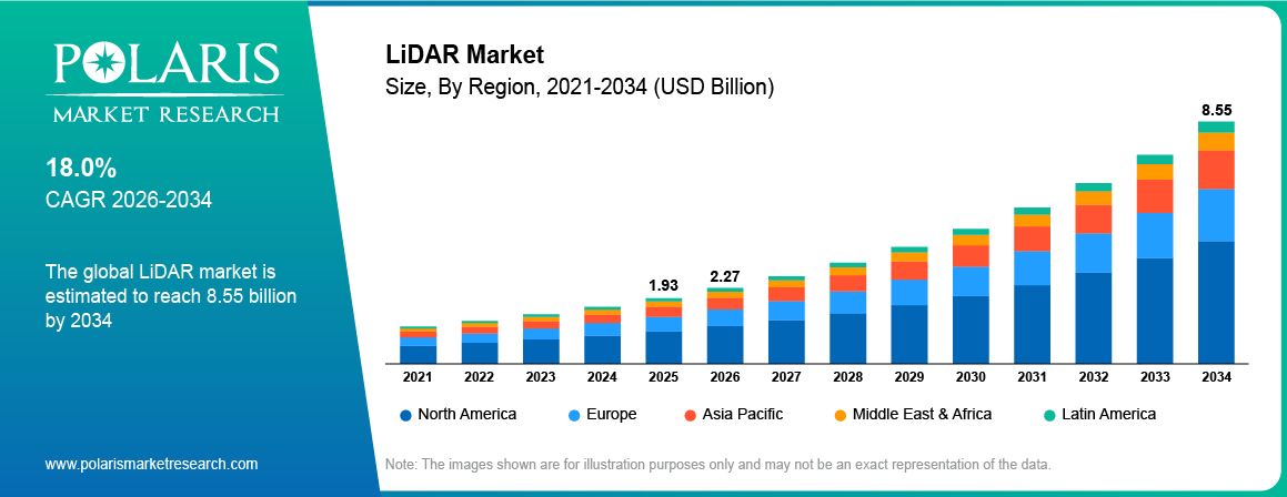
The light detection and ranging (LiDAR) market size was valued at USD 1.93 billion in 2025 and is projected to register a CAGR of 18.0% from 2026 to 2034. The market is experiencing robust growth driven by the increasing need for 3D visuals in various industries, such as military & defense, land surveys, civil engineering, and route mapping. Moreover, LiDAR technology facilitates environmental monitoring in smart cities. This data facilitates sustainable urban development, thus boosting the adoption of LiDAR systems.
Market Statistics
Key Takeaways
- North America held a substantial share of 31.4% in 2025. This is attributed to the increasing regulatory requirements for the installation of automotive safety technologies in light and heavy vehicles.
- The Asia Pacific LiDAR industry is expected to register the highest CAGR of 18.6% from 2026 to 2034. This is attributed to urbanization and infrastructure development in countries such as China, Japan, and India.
- In 2025, the short range (<200m) segment dominated with a 44.3% share. The leading position is attributed to its applications in manufacturing settings and industrial automation.
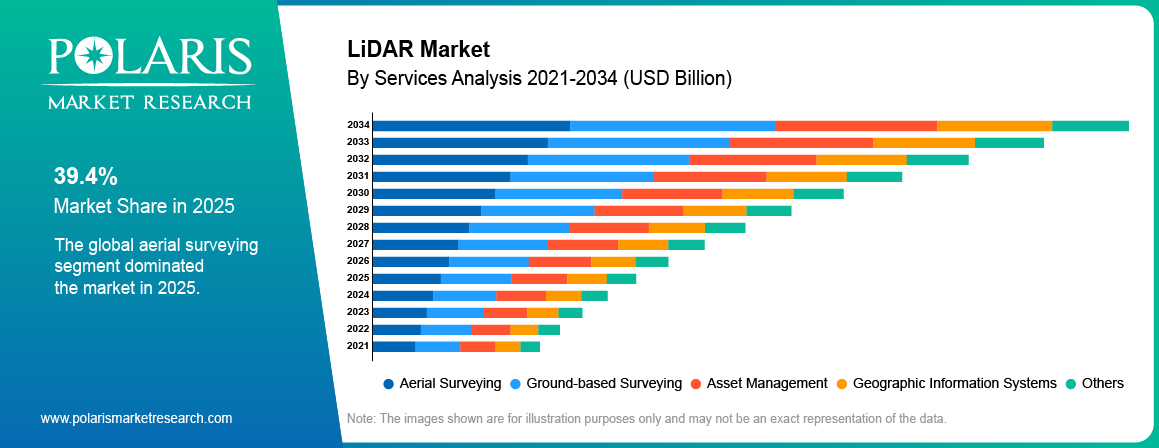
- The aerial surveying segment dominated with a 39.4% share in 2025. It is driven by its application in monitoring incidents in various areas such as roads, railways, highways, and bridges.
- The solid-state segment is projected to register rapid growth at an 18.3% CAGR during the projected period. Solid-state LiDAR is significantly cheaper to manufacture at scale compared to complex mechanical systems.
Note: Figures and projections outlined in this report are the result of Polaris Market Research’s proprietary analytical processes, grounded in the latest available datasets and market observations.
What is LiDAR?
Light Detection and Ranging, or LiDAR, is an advanced form of remote sensing. LiDAR uses a laser beam to calculate distances. Individual LiDAR instruments use thousands or even millions of laser pulses.
By measuring the time it takes for the light beams to return to the sensor, LiDAR creates a 3-D model of the environment. LiDAR technology is utilized in various industries such as automotive, construction, surveying, robotics, agriculture, mining, and military. For instance, in the automotive industry, cars use LiDAR sensors to distinguish between the road, other cars, people, and objects. Additionally, LiDAR sensors are accurate and can perform under various conditions like daylight or darkness.
The laser scanners, crucial components of LiDAR, are another major contributor to the expansion of the LiDAR market size. They are capable of capturing intensity values to provide return signal strength, allowing for the differentiation of objects with different levels of reflectivity. LiDAR laser scanners generate 2D point cloud data used in tasks such as localization, mapping, and environmental modeling. Moreover, laser scanner manufacturers are investing heavily in technology which is improving the scanner appeal.
How LiDAR Works
LiDAR is a ranging technology which uses light beams. LiDARs emit narrow beams of light toward objects to be measured. A part of that light is reflected off the surface of the object. LiDARs then measure the time that it takes for that light to be reflected and determine the distance to the object based on that information. By using multiple individual measurements, LiDAR constructs images of objects that they are pointed at. Using those images, one can discern objects such as buildings, cars, vegetation, and other features.
LiDAR Types and Applications
| LiDAR Category | Main Characteristics | Possible Uses |
| Mechanical LiDAR | Sensors rotate, broad coverage | Autonomous driving, surveying |
| Solid-state LiDAR | Does not contain any moving parts, small size | ADAS, robotics, drones |
| Airborne LiDAR | Fitted onto an airplane or drone | Terrain surveys, forestry LiDAR |
| Bathymetric LiDAR | Measures both land and shallow water surfaces | Coastal mapping, flood studies |
Source: Polaris Market Research Analysis
Market Dynamics
Driver: Integration of Artificial Intelligence (AI)
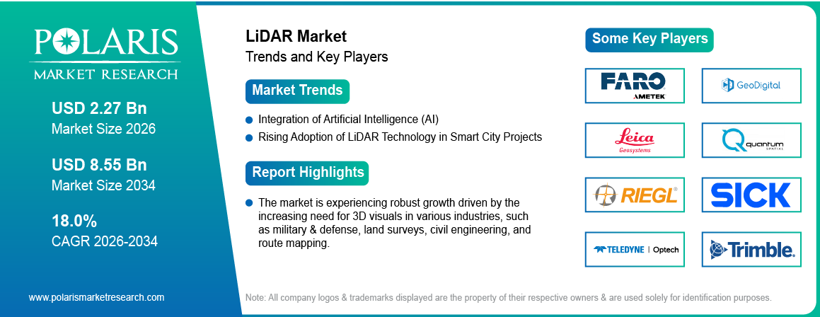
The rising LiDAR market CAGR is supported by the incorporation of artificial intelligence into LiDAR technology. This integration is enhancing the capabilities and applications of LiDAR systems across various industries. AI-enabled LiDAR systems are being utilized to process large volumes of data more efficiently and accurately.
The use of AI algorithms enables LiDAR to better interpret and analyze 3D spatial data in real time. It leads to improved autonomous navigation for vehicles, drones, defense, and robots. For instance, in April 2026, Artec 3D launched Artec Jet. It combines SLAM, LiDAR, and AI for fully autonomous 3D mapping. LiDAR are use to provide precise, active 3D distance measurement and depth perception that complement cameras in complex traffic. It enables enhanced mission planning, navigation, and threat evaluation for defense operations (Source: metrology.news).
AI integration in LiDAR helps overcome limitations like data interpretation speed and complexity. This optimization enhances LiDAR systems by enabling predictive capabilities and adaptive responses as AI advances. Thus, rising AI integration with LiDAR drives market expansion.
Driver: Rising Adoption of LiDAR Technology in Smart City Projects
The increasing implementation of smart city projects for urban planning, development, and management drives the LiDAR market growth. According to the Government of India, Ministry of Housing and Urban Affairs, 95% of total smart city projects in the Indian state of Maharashtra have been completed as on January 2026 (Source: sansad.in).
In smart cities, LiDAR technology is used in urban planning to create detailed 3D maps of city landscapes. This helps city planners visualize existing structures, design new projects, and improve land utilization. Thus, the rising emphasis on developing smart cities fuels LiDAR adoption.
Restraint: High Cost of LiDAR Adoption
The high costs of developing, installing, and maintaining LiDAR technology limit its adoption. The cost factor is significantly affected by the technical complexity of the technology and the equipment required for implementation. Reduced research and development budgets and high implementation costs significantly restrain LiDAR market growth. The technology relies heavily on sensors and their associated software and hardware, which increases overall cost. Additionally, the cost of LiDAR is a major concern in the automotive and consumer electronics industry.
Restraint: Technical Limitations
The technical limitations of LiDAR sensors restrain market growth. The technology has proven to be unreliable under bad weather conditions such as rain, snow, fog, and dust. Objects and distances have to be manually entered and calculated. LiDAR sensors require additional software to process the data they collect. This adds complexity and increases power consumption. Moreover, some manufacturers choose low-cost and easily available solutions, such as cameras and radar, over LiDAR sensors. These aspects hinder the industry growth.
Opportunity: Increasing Demand for Autonomous Vehicles
Autonomous vehicles present a significant growth opportunity for the LiDAR sensor market. The rising trend of self-driving cars and the need for improved safety features and advanced driver assistance systems (ADAS) would propel LiDAR demand. The technology enables autonomous vehicles and robots to navigate their environment safely. Several automakers and technology companies are currently working on improved vehicle safety technologies. As the technology advances and becomes more compact, cost-effective, and energy efficient, its application in the automotive industry is expected to grow in the coming years.
Real-World Use Cases of LiDAR
| Date | Named Example | Real-World Application of LiDAR | How LiDAR was used |
| May 1, 2025 | Aurora Driver for Freight – Texas | Autonomous heavy-duty trucking | Aurora’s driverless trucks used LiDAR with cameras and radar to identify vehicles, pedestrians, road debris, and other road objects during commercial freight operations between Dallas and Houston. (Source: ir.aurora.tech) |
| April 26, 2025 | LiDAR-Based Road Cracking Detection – Interstate I-65, Indiana | Automated pavement inspection and maintenance | Mobile LiDAR data from I-65 near West Lafayette was processed using machine learning to identify longitudinal and transverse pavement cracks and support road-maintenance planning.(Source: mdpi.com) |
| June 10, 2025 | Rengasdengklok Arterial Road, Indonesia | Drone-based road-condition monitoring | Drone-mounted LiDAR was used to evaluate road surface conditions and classify damage on the Rengasdengklok Arterial Road, enabling faster infrastructure assessment than conventional field surveys. (Source: discovery.researcher.life) |
| 2025 | Calgary Bow and Elbow Rivers Bathymetric Survey | Flood modelling and river-infrastructure planning | Bathymetric LiDAR captured high-resolution riverbed and surrounding terrain data to support flood-risk assessment, erosion monitoring, and infrastructure planning in Calgary. |
Source: Polaris Market Research Analysis
Segment Analysis
Assessment by Measurement Technology
Time-of-Flight is expected to witness significant growth of CAGR 18.7% during the forecast period due to the accuracy of the measurement results. This technology determines the distance to the object by the time of the light signal travel. The growing need for precise measurements fuels the use of time-of-flight sensors in research, automotive, surveying, and construction. The technology allows for obtaining reliable 3D information about the environment at a considerable distance and is used extensively in various fields. Moreover, a decrease in the cost of sensors and an increase in their performance fuels the adoption, thereby driving the segment growth.
FMCW Vs Time of Flight LiDAR
| Technology | Scanning Method | Typical Range | Cost Trend | Primary Use Case |
| FMCW LiDAR (frequency-modulated continuous wave) | Continuous-wave laser with Doppler velocity sensing | Long, with direct velocity data | Currently premium-priced | Highway-speed ADAS, velocity-critical automotive |
| Time-of-Flight LiDAR (ToF) / Phase-shift | Pulse or phase-based distance measurement | Short–long depending on implementation | Low-to-moderate | General-purpose ranging across automotive, industrial, and consumer |
Source: Polaris Market Research Analysis
Assessment by Architecture
MEMS is expected to witness growth of CAGR 19.2% during the forecast period due to its small size and ability to steer laser beams. The architecture allows for designing highly miniaturized LiDARs for the automobile, robotics, and drone industries. The MEMS LiDAR design allows for creating a sensor that scan the scene at a much larger field of view. The increasing need for miniature and lightweight LiDARs is fueling automakers and robot manufacturers to adopt this technology. Furthermore, developments inMEMS allow for higher yields of LiDARs during the manufacturing process, making them more affordable for a broader range of customers, thereby driving the segment growth.
By Architecture Comparison
| Technology | Scanning Method | Typical Range | Cost Trend | Primary Use Case |
| MEMS solid-state | Micro-mirror beam steering, no full rotation | Medium (150–250m) | Falling toward automotive-grade sub-USD 500 by ~2028 | Automotive ADAS LiDAR, robotics |
| Optical Phased Array (OPA) | Electronic beam steering, no moving parts | Short–medium | High R&D cost today, long-term miniaturization potential | Compact robotics, drones |
| Flash LiDAR | Single-pulse full-scene illumination | Short (<100m) | Low-cost at scale | Indoor robotics, short-range obstacle detection |
Source: Polaris Market Research Analysis
Assessment by Installation
Ground-based dominated the LiDAR market share by installation type by holding 48.6% in 2025. It is used in surveying, civil engineering, mining, and road construction. It allows obtaining high-precision 3D models of the study area, which is important for engineers and surveyors who measure topography to create maps and diagrams. Moreover, this mining LiDAR is used in mining companies for geological analysis and work supervision. The growing need for 3D data acquisition for engineering, construction, and mining communities drives the demand for ground LiDAR. There is a growing trend for automated rapid surveys using LiDAR equipment. As a result, it becomes possible to obtain valuable data for the analysis of topography with high precision and speed.
Assessment by Range
The LiDAR market segmentation, based on range, includes short range (< 200m), medium range (200-500m) and long range (> 500m). In 2025, the short range (< 200m) segment dominated the LiDAR market size with 44.3% share, mainly attributed to its applications in manufacturing settings and industrial automation. Short range LiDARs can sense object proximity and detect objects within the 0–200 m range to enhance operational safety and efficiency.
Short range LiDAR systems are integrated into robotics, drones, and autonomous vehicles for obstacle detection and avoidance in close proximity, contributing to system safety. The increasing use of short range LiDARs in various sectors, such as automotive, security, and industrial robotics, is driving the growth of the short-range segment in the LiDAR market.
Evaluation by Services
The LiDAR market segmentation, based on services, includes aerial surveying, ground-based surveying, asset management, geographic information systems, and others. In 2025, the aerial surveying segment dominated the market with 39.4% share, owing to its application in monitoring incidents in various areas like roads, railways, highways, and bridges.
Aerial surveying provides highly accurate 3D mapping of terrains and landscapes, offering precise results for site inspections. These surveys can be conducted using either manned or unmanned aerial systems, such as drones and aircraft. Typically, government agencies are responsible for carrying out these services.
For instance, in September 2026, GeoCue Launched TrueView 550 which is an aerial LiDAR system. The product contains LiDAR and dual mapping cameras specifically for the surveys and mapping (Source: dronelife.com).
Regional Insights
By region, the study provides market insights into North America, Europe, Asia Pacific, Latin America, and the Middle East & Africa.
North America
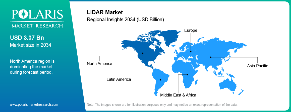
North America dominated the global LiDAR market share with 31.4% in 2025. The leading position is attributed to the rising need in autonomous vehicles and ADAS. The development of this technology is majorly driven by the growing industrial robots, surveying and mapping, and construction and building sectors. The region witnessed a significant amount of investments in transportation and infrastructure, supported by government policies that boost the sales of LiDAR sensors. Furthermore, North America has several major technology companies and research facilities. These factors boost investments in developing new LiDAR technologies.
U.S.
The US LiDAR market dominated with 51.28% share in North America in 2025. It is driven by increasing investments in autonomous cars and driver assistance systems. The region has witnessed a surge in the application of LiDAR in mapping, construction, robotics, and defense. The development of infrastructure is expected to create significant demand for LiDAR sensors. Strong investments from major automotive and technology companies would boost the industry growth.
Asia Pacific
The Asia Pacific LiDAR market is expected to record the highest CAGR of 18.6% during the forecast period. This is due to rising demand from the automobile sector and infrastructure development across APAC. The growing need for autonomous machines, drones, and industrial robots is further contributing to the demand for LiDAR sensors in the region. Moreover, the governments of APAC countries are investing significantly in the development of transportation infrastructure, smart cities, and digital mapping systems that are further supporting the growth. The rising automotive production and falling sensor prices are fueling the LiDAR market in the region.
China
The China LiDAR market is expected to witness a 21.3% CAGR during the forecast period. The growth is driven by rising demand from electric vehicles and driver-assistance systems. The growing automotive sector in China is fueling investments in LiDAR sensors. The government of China is promoting the development of intelligent transportation systems and autonomous vehicles LiDAR, which is anticipated to fuel the demand for LiDAR. Increased need for industrial robots, surveying, and mapping is further expected to bolster the market in China.
India
The India LiDAR market is witnessing a 22.1% CAGR during the forecast period due to growing demand from the infrastructure development and surveying and mapping sectors. The Indian government has been investing significantly in developing roads, railways, and smart cities, as well as digital mapping systems. Consequently, the demand for LiDAR sensors is rising as they are being used for topographic surveys and construction monitoring.
Japan
The Japan LiDAR market is expected to exhibit a CAGR of 17.4% during the forecast period. It is driven by the country’s large automobile and robotics industries. Demand for LiDAR is mainly driven by the need for advanced driver-assistance systems. Growth in industrial robot installations and the rise of the robotics industry further contribute to the demand for LiDAR sensors. Moreover, a need for UAV LiDAR survey, smart mobility, and mapping stimulates the market in the country.
Europe
The Europe LiDAR market is expected to witness a 17.2% CAGR during the forecast period. The growth is supported by the strong local automobile industry, which is investing and partnering in the development of driverless cars and advanced driver-assistance systems. For instance, in August 2026, Uber and Pony AI formed a strategic partnership to deploy 2,000 robotaxis in Europe. LiDAR is used in robo taxi to provide precise, active 3D depth measurement and redundancy. This helps autonomous vehicles navigate safely without a human driver. Therefore, thr rising adoption of robotaxis in Europe drives the market expansion.
The growing need for LiDAR sensors in various applications such as surveying, construction, and industrial automation is rising. This is driven by government spending on smart mobility and infrastructure projects. Additionally, a rise in automotive safety awareness and the need for automated transport solutions further drive the market (Source: cnbc.com)
Germany
The Germany LiDAR market is expected to witness a CAGR of 16.8% during the forecast period. The expansion is due to the presence of the local automobile industry and its growing need for LiDAR sensors in the development of driverless cars and ADAS. The increase in the use of these sensors in industrial automation and robotics is further driving the growth in the country. A rise in government investments in smart mobility and infrastructure development is also anticipated to increase the demand for LiDAR sensors in the local automobile and industrial sectors.
LiDAR Value Chain Analysis
The LiDAR industry value chain comprises several stages. The first stage is represented by material suppliers. They provide sensors, lasers, chips, and other electronic parts. The second stage is constituted by LiDAR companies that design and develop LiDAR systems and technologies. These companies create LiDAR products by combining different elements.
The third stage in the value chain is LiDAR manufacturing. It is the process of fabrication, assembling, constructing, and testing LiDAR sensors. The fourth stage is LiDAR selling. Products are delivered to the marketplace via direct sales, distributors, and technology partners.
LiDAR systems are further integrated into different areas and applications. The value chain’s fifth stage is system integration, which refers to the incorporation of LiDAR technology into cars, robots, drones, surveying systems, and other equipment. In addition, software is needed for the LiDAR systems’ proper functioning.
The sixth stage is the LiDAR sensor supply chain to end-users, who are manufacturers of automotive, construction equipment, surveying instruments, government, and technology companies. There are also service providers, who deliver services connected with surveying and inspection. Multiple companies are involved in designing, developing, producing, selling, and providing after-sales support for LiDAR systems.
Competitive Analysis Report
Key LiDAR companies are investing heavily in research and development to expand their product lines, which will further drive LiDAR market growth. Market participants are also undertaking a variety of strategic activities to expand their global footprint, with important market developments including new product launches, contractual agreements, mergers and acquisitions, higher investments, and collaboration with other organizations. To expand and survive in a more competitive and rising market climate, the LiDAR market must offer cost-effective items.
Manufacturing locally to minimize operational costs is one of the key business tactics used by LiDAR manufacturers in the global market. It helps them benefit clients and expand their business.
List of Top LiDAR Companies 2026
- Aeva Technologies, Inc.
- Aeye, Inc.
- FARO Technologies, Inc.
- GeoDigital
- Innoviz Technologies Ltd.
- Leica Geosystem Holdings AG (Hexagon AB)
- Ouster, Inc.
- Quantum Computing Inc. (Luminar)
- Quantum Spatial, Inc.
- RIEGL USA, Inc.
- RoboSense
- SICK AG
- Teledyne Optech Incorporated
- Trimble Inc.
- YellowScan
Vendor Positioning
| Company | Position | Differentiator |
| Trimble Navigation Limited | Leader | Professional geospatial survey-to-GIS workflow; deep AEC vertical penetration |
| Leica Geosystem Holdings AG (Hexagon) | Leader | Premium terrestrial/mobile/bathymetric mapping; part of the Hexagon ecosystem |
| Hesai Group | Challenger | Highest unit volume globally; vertically integrated ASIC and optics manufacturing |
| Ouster Inc. | Challenger | Digital-native solid-state architecture; dual robotics/AV go-to-market |
| RoboSense LiDAR | Challenger | China domestic volume leader; fast international robotics expansion |
| Innoviz Technologies Ltd. | Emerging | Automotive-qualified (IATF 16949) solid-state MEMS; BMW series-production supply |
| Quantum Computing Inc. | Emerging | Quantum-photonics sensing approach; acquired Luminar's semiconductor assets in the Luminar wind-down |
| FARO Technologies, Inc. | Established / Niche | Software-driven 3D measurement and industrial scanning, not automotive-focused |
| Sick AG / RIEGL USA, Inc. / Teledyne Optech | Established / Niche | Industrial safety sensing, professional aerial/marine survey instruments |
Source: Polaris Market Research Analysis
LiDAR Recent Developments
- June 2026: STMicroelectronics launched the VL53L9, a compact direct Time-of-Flight 3D LiDAR module. The module offers 2,268 zones, a wide field of view, up to 100 frames per second, and sensing up to 9 meters for robotics, automation, and smart buildings. (Source: newsroom.st.com)
- April 2026: Hexagon AB's green-tech venture, R-evolution, launched airborne missions at Vale mine sites in Brazil using Leica Geosystems' hybrid LiDAR and imaging technology. The initiative, named Green Cubes, creates high-fidelity digital twins of habitats to support biodiversity monitoring and rehabilitation. (source: hexagon.com)
- March 2026: AEye joined the NVIDIA Halos AI Systems Inspection Lab to integrate its Apollo LiDAR with NVIDIA DRIVE platforms. According to AEye¸ Apollo LiDAR is designed to work with NVIDIA DRIVE AGX Orin and Thor platforms. It enhances object detection at ranges up to 1 kilometer. (source: www.aeye.ai)
- March 2026: 3DMakerpro launched the Eagle LiDAR Scanner in March 2026. The scanner integrated Livox’s Mid-360 LiDAR sensor with four fisheye cameras for real-time 3D data capture and color mapping. Its lightweight design supported handheld, backpack, bicycle, and motorcycle-based surveying applications. (Source: livoxtech.com)
- March 2025: Ouster launched 3D Zone Monitoring for its REV7 digital LiDAR sensors, including OS0, OS1, and OSDome. The firmware-based feature enables real-time object detection in custom 3D zones, enhancing collision avoidance in warehouse automation and industrial robotics while supporting Ouster’s shift toward autonomy-focused solutions. (Source: investors.ouster.com)
Future of LiDAR Market
As per our LiDAR market forecast, the market is expected to grow significantly in the coming years. The growth is driven by the widespread adoption of LiDAR in autonomous vehicles, robotics, drones, and smart cities. The implementation of AI technology will improve the capabilities for processing real-time data, navigation, and decision making. Lower costs and solid-state LiDAR sensor advancements are expected to contribute to commercial success. Further use cases in the logistics, construction, surveying and environmental monitoring sectors are expected to create lucrative opportunities in the coming years.
Research Methodology
- Market estimates are derived using a blend of primary and secondary research, validated through weighted-average and combined top-down/bottom-up modeling approaches.
- Secondary research covers vendor filings, autonomous vehicle and ADAS deployment data, geospatial mapping and surveying investments, industry journals, and paid third-party databases to build baseline estimates.
- Primary research includes interviews with key industry participants such as LiDAR sensor manufacturers, automotive OEMs, surveying and mapping service providers, and photonics component suppliers, to validate accuracy and capture forward-looking insights.
- Base year considered is 2025, with a forecast provided through 2034; revenues are expressed in USD Billion.
- Parent market is identified as the global remote sensing and 3D imaging market; the addressable segment is narrowed using LiDAR adoption rates across automotive, industrial, and geospatial applications.
- Bottom-up model aggregates regional LiDAR demand across measurement technology, architecture, type, component, range, installation, services, and application, validated against vendor revenue disclosures from Ouster, RoboSense, Trimble, Hexagon, Teledyne, and others.
- Regional coverage spans North America, Europe, Asia Pacific, Middle East & Africa, and Latin America, further segmented by major countries.
- Projected 18.0% CAGR (2026–2034) reflects weighted analysis of growing ADAS and autonomous driving adoption, declining solid-state LiDAR costs, expanding smart city and infrastructure mapping projects, and advancements in FMCW and MEMS-based sensing technologies.
- Findings are cross-validated across multiple estimation methods to ensure consistency, accuracy, and reliability of the final market sizing.
Light Detection and Ranging Market Segmentation
By Measurement Technology Outlook (Revenue – USD Billion, 2021–2034)
- FMCW
- Time-of-Flight
- Phase-shift
By Architecture Outlook (Revenue – USD Billion, 2021–2034)
- MEMS
- OPA
- Flash
By Type Outlook (Revenue – USD Billion, 2021–2034)
- Solid-state
- Mechanical
By Component Outlook (Revenue – USD Billion, 2021–2034)
- Navigation & Positioning Systems
- Laser Scanners
- Others
By Range Outlook (Revenue – USD Billion, 2021–2034)
- Short Range (< 200m)
- Medium Range (200-500m)
- Long Range (> 500m)
By Installation Outlook (Revenue – USD Billion, 2021–2034)
- Ground-Based
- Static
- Mobile
- Airborne
- Bathymetric
- Topographic
By Services Outlook (Revenue – USD Billion, 2021–2034)
- Aerial Surveying
- Ground-based Surveying
- Asset Management
- Geographic Information Systems
- Others
By Application Outlook (Revenue – USD Billion, 2021–2034)
- Urban Planning
- ADAS & Driverless Cars
- Corridor Mapping
- Environment
- Engineering
- Exploration
- Meteorology
- Others
By Regional Outlook (Revenue – USD Billion, 2021–2034)
- North America
- U.S.
- Canada
- Europe
- Germany
- France
- UK
- Italy
- Spain
- Netherlands
- Russia
- Rest of Europe
- Asia Pacific
- China
- Japan
- India
- Malaysia
- South Korea
- Indonesia
- Australia
- Vietnam
- Rest of Asia Pacific
- Middle East & Africa
- Saudi Arabia
- UAE
- Israel
- South Africa
- Rest of the Middle East & Africa
- Latin America
- Mexico
- Brazil
- Argentina
- Rest of Latin America
LiDAR Market Report Scope
| Report Attributes | Details |
| Market Size in 2025 | USD 1.93 billion |
| Market Size in 2026 | USD 2.27 billion |
| Revenue Forecast in 2034 | USD 8.55 billion |
| CAGR | 18.0% from 2026 to 2034 |
| Base Year | 2025 |
| Historical Data | 2021–2024 |
| Forecast Period | 2026–2034 |
| Quantitative Units | Revenue in USD Billion and CAGR from 2026 to 2034 |
| Report Coverage | Revenue Forecast, Market Competitive Landscape, Growth Factors, and Trends |
| Segments Covered |
|
| Regional Scope |
|
| Competitive Landscape |
|
| Report Format |
|
| Customization | Report customization as per your requirements with respect to countries, regions, and segmentation. |
Source: Polaris Market Research Analysis
LiDAR Market FAQ's
The LiDAR market size was valued at USD 1.93 billion in 2025 and is projected to be valued at USD 8.55 billion in 2034.
The market is projected to grow at a CAGR of 18.0% from 2026 to 2034.
North America had the largest share of the market.
The key players in the market are FARO Technologies, Inc.; GeoDigital; Leica Geosystem Holdings AG; Quantum Spatial, Inc.; RIEGL USA, Inc.; Sick AG; Teledyne Optech Incorporated; Trimble Navigation Limited; Velodyne LiDAR, Inc.; and YellowScan.
The short range (< 200m) segment dominated the market in 2025.
The aerial surveying segment held the largest market share in 2025.
LiDAR (Light Detection and Ranging) is a remote sensing technology that measures distances by emitting laser pulses and analyzing reflections, generating precise three-dimensional information about object shapes and landscape surface characteristics.
North America leads the market with 31.4% share in 2025.
Time-of-Flight leads adoption, while FMCW, Phase-Shift, MEMS, OPA, and Flash technologies gain demand across diverse applications.
LiDAR provides detailed three-dimensional data, while radar offers stronger performance in adverse weather and longer-range detection applications.
Automotive LiDAR focuses on real-time object detection, while surveying LiDAR emphasizes accurate mapping, measurement, and detailed terrain data.
Download Sample Report of LiDAR Market
Please fill out the form to request a customized copy of the research report.


